Today's New York Times has a very interesting article about China Lake Petroglyphs. China Lake is a military base adjacent Death Valley in the Mojave Desert. Now I have another good reason to return to California and explore this wonder!
Rock Art Redefines 'Ancient'
Friday, December 18, 2009
Sunday, December 6, 2009
Travels with Charley in Search of America
For those who like to read books about travel, I recommend John Steinbeck's "Travels with Charley in Search of America." I read this after returning from my trip and was amazed at the number of similar thoughts I had while traveling.
The book is about his three month journey across America with his dog Charley in 1960. He had a camper made to order for his trip and took a different route but left right after Labor Day, as I did.
Here's a link to Amazon for Travels with Charley.
The book is about his three month journey across America with his dog Charley in 1960. He had a camper made to order for his trip and took a different route but left right after Labor Day, as I did.
Here's a link to Amazon for Travels with Charley.
Saturday, December 5, 2009
Pittston, PA to Home
 |
| Day 47 Photo Album |
October 19, 2009
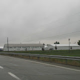
The motel in Pittston was the pits. I couldn’t wait to leave in the morning, so I set out at sunrise, set to beat the rush hour traffic in Boston.
Driving in the morning is wonderful. Light is breaking across the land with sweetness and promise. The night’s remains linger in the shadows as dew or frost. Fog rises from the valley floor and looks for a new form before your eyes. This fog has followed me across the continent and calls me back to another coast, I hear its voice and listen. Always turning over the places I set foot or wheel in. There is so much to think about now.
But the traffic pounded out most thoughts during the day. Before I knew it, I was back in the flow of people elbowing their way around the lanes.
I stopped in Danbury, Connecticut around 10 a.m. to have a longer rest, leaning back in the car. After a while, a man tried to get into the car, thinking it was his. Good thing I locked it! He was very sorry, it seems he had a rental car and got confused. Pretty funny actually. It was time to go anyway.
The last thing I wanted was to sit in traffic along I-95, so I pushed really hard to get beyond it by 2 p.m. My eyes were weary, my mind was trying to hold on to those lovely days in the desert, or corn fields, or anywhere other than a city. I’ve concluded that people are all the same everywhere, when they get too condensed, they tend to behave badly. Why this is, I have no idea. I have a theory that it just isn’t natural for so many people to be so close together.
At 1:52 p.m. while crossing Route 2, I had gone 9,000 miles. I got home at 2:30 p.m. with a final marker of 9,033.9.
It was very odd to park my car in my spot, walk inside, and actually be home. Even now, 5 hours later, something seems odd. Oh, that’s me.
The most remarkable aspect of my journey was the response from my family and friends who followed the journey through my blog, by phone, and during visits. They surprised me with their enjoyment and wonder at what I was doing, their appreciation of my daily reports, and the completely positive support for my choices.
I’m certain this won’t be the last journey I make!
Friday, December 4, 2009
Uniontown to Pittston, Pennsylvania
 |
| Day 46 Photo Album |
October 18, 2009
My decision to stay in the Blue Mountain Motel was a good one. It was tiny but cozy and personal. I don’t really like hotels or motels. The bedspread was a pure white quilt, the sheets were flowered, and there were four pillows! The walls had framed work that seemed personal to the owner. There are only eight units and the owners’ house has a bell to ring for service. The screen doors are all battered and the place needs work, but somehow all this combines to make a psychologically satisfying stay.
I was off just after daylight, which is 7:30 a.m. in this geographic location. It was 38 degrees when I departed and still cloudy. Not many people out and about so it seemed as though I was wandering through ghost towns as I made my way up Route 119. I noticed that in Uniontown, a person named Palumbo was running for city council. As I was zig-zagging through detours and alternate route signs I didn’t stop to take many pictures. I believe this is a coal mining area and though there are some weary areas there was still a feeling of stable communities. All assumptions based on nothing but looks and feelings.
The route was filled with farm country, small towns, and gorgeous countryside. The leaves were perfect. I’ve been to many places along I-76 back in my days of abode in Philadelphia, so I wanted to take this western, northern route to I-80 for a change of scenery.
As I didn’t have any internet access last night I had to watch the weather channel and their dire predictions were of snow and rain all day all across Pennsylvania. My forecast was for a sunny day because I really needed it. About an hour into my drive the sun began to peek out of the clouds and I shouted in my sister’s ear to declare victory (via phone, of course). It took another hour or so for the damn clouds to clear out and become lovely poofs to look at against deep blue sky. Deep Blue Sky! That’s another thing I haven’t seen for 10 days!
Without realizing it, Punxsutawny was on my path. I felt a bit like a groundhog today, coming out of my cloud burrow to see my shadow. Though I must say, I have observed shadows under cars on the highway even under heavy clouds. One of the bizarre things my mind notices. I stopped for gas at one of the chains in Pennsylvania called Sheetz. Pennsylvania has some of the funnest names for things and places.
I was soon on the interstate and began to notice that they are the fastest drivers I’ve encountered so far. I stick to the speed limit, which was 65. Everybody was zooming around me; fine with me, go ahead. But when there is only one lane, like around Wilkes-Barre where I tried to find a motel, they are dangerous. Passing in no-passing zones, riding my bumper, nutty.
The landscape of mountains was full of color and after a while they widen and become longer. I could see mesas stretching out and jutting up instead of wearing down. Or all the smaller waves of hills from West Virginia melding together and forming a long chain. What if you combine the mesas of New Mexico with the lushness of the east?
Clearly it is time to be home and start creating my own landscapes. I’m 333 miles from home now, having landed in Pittston, Pennsylvania. I had hoped to stop at my friend’s house in Connecticut on the way, but she has other obligations tomorrow, so I’m on a straight line home.
At this point I have transitioned from not wanting to go home to looking forward to getting there. After that, a whole lot of thinking and creating will begin.
Thursday, December 3, 2009
North through West Virginia
 |
| Day 45 Photo Album |
October 17, 2009
The extra day at rest was uneventful, at least to the public. Internally, when I stay still the past surges up and unexpected connections with my ancient past collide with future events. The weather continued to be stubbornly thick, cold, and rainy. My cabin was nice and warm and all my laundry all clean.
So I rose early and looked forward to moving again. I’ll say this for the weather: at least it DID something today. Instead of unmoving heavy clouds, they moved about, rained, cleared ever so slightly, and drug fog along the ground. Indeed, by the time I got to Uniontown, Pennsylvania, the fog was so thick it was hard to see.
Energy was aggressively hyper along I-79 as there is a college football game between two rival West Virginia teams in Morgantown. I shall refrain from exaggerating the number of cars with flags, emblems and whatnot on the road. It seemed like 80% of them, so I’ll say 50%. They were at all the rest stops, hopping like over-caffeinated Wall Street brokers to do their business and get back on the road. More than once I passed a car stopped on the side of the road to pick up their little flags that had blown off their cars.
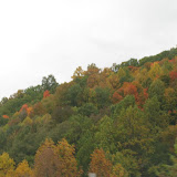
I thoroughly enjoyed my drive. The trees were perfectly balanced between all shades of green, yellow and orange. The road weaves splendidly among the waves of hills. To me the hills here seem smaller, more numerous and more pointed. I imagined myself within a tree ocean, riding the troughs of waves. Sometimes the trees give way to a bit of rich green grass and a house tucked into the edge. The highway was remarkably free of billboards.
I intended to turn off at a Route that would take me directly to Uniontown, but there was no forewarning and I missed it. So I had to go a bit further and backtrack. I was headed for Pennsylvania Route 40 and it was great to be on a two lane road for the last leg of the trip.
There is a Frank Lloyd Wright designed house right near here, but I didn’t check it out today as the fog was so thick and the temperature was dropping to freezing. So I found a hide-away motel called Blue Mountain and tucked myself in at 3 pm. No internet connection, but I watched the Weather Channel and my intended route for tomorrow is right in the path of the Nor’easter spreading its wings across all of the northeast. Still no sun predicted until Monday when I hope to make my final journey home.
Wednesday, December 2, 2009
Mt. Vernon to the End of Kentucky
 |
| Day 43 Photo Album |
October 15, 2009
I should have been more specific about the state when I speak of cities; it seems that there are duplicates. As I began my day I did a double take over the border in Indiana: signs for Mt. Vernon and Boonville (places I had driven through in Illinois) were posted. Hey, am I going the wrong direction?
This happened at the border of Kansas and Illinois too. I saw signs for O’Fallon before getting to Kansas City (which is duplicated right next to itself as well) then as I headed out of Indepedence I saw another sign for O’Fallon in Missouri, just about the same distance from Kansas City as the other one.
This makes me wonder if borders cause a mirroring affect.
My stay was in Mt Vernon, Illinois. The usual heavy cloud cover stayed with me all day. A bit of rain again, not serious. The corn is dried out, but apparently not dried out enough. My father says that to harvest corn for grain it needs to get to the optimum moisture content so that it stores well. I believe this is between 15% and 16%. There seemed to be a lot of orange and yellow in the landscape of crops which may be soybeans. It was beautiful to me. Folds of gentle slopes dipping and weaving in and out of each other amidst stands of trees and farm buildings, their colors changing from yellow to orange to green. Then a vast open space of corn with a line of distant trees to hold it in the frame.
Oil pumps are in the fields of Illinois and Indiana as well. Just one or two here and there. Right in the middle of the crops. This fascinates me.
Then the highway will be enclosed by a tunnel of trees. It was fun.
Indiana billboards informed me that I could visit the Marengo Caves which are a National Landmark. I wondered why I would do such a thing on such an overcast day. But when I stopped for a rest at the exit for Marengo I changed my mind and ventured ten miles north off the highway to walk underground. After all, I’ve never been in a cave and I could use a walk.
This was a very weird experience. The tour covers over a mile of the cave. Though they are careful about people touching things and leaving trash behind, it hasn’t always been that way. When the caves were first discovered they were used for all kinds of events: concerts, plays, square dancing, boy scout sleepovers, and more. The kids still get to do quite a lot more than the tour, which is pretty exciting for them.
Some of the spaces are small enough you have to duck, but for the most part it is a passageway that leads into multiple large areas (where all the fun used to transpire). I was enjoying the weirdness of it and taking photos like a nut, hoping something would turn out.
When I came outside I suddenly found I could breathe much freer. It hadn’t occurred to me until then that I was feeling a bit tense down there. Especially from the point where she showed us how the ceiling falls down every once in a while to create various layers. Oh yes, and she was told it was safer to be underground during an earthquake. I’m going to have to look into that assertion.
The clouds and dullness of the day seemed infinitely more cheerful for the remainder of the day.
Into Kentucky I started to see those beautiful green grasses and black fences. Didn’t see many white fences. What I really enjoyed was the way the hills were shaped and how the highway flowed in and out of them. The colors are still turning with just a few places where the trees are bare.
My energy was good so I drove on a bit after dark and found the KOA west of Ashland, Kentucky, right before the border of West Virginia. To my delighted surprise I found their cabins have bathrooms! What a lovely cabin I’ve got! So I’ve decided to stay a day here and rest up while the snow blows out of Pennsylvania.
The snow and rain are covering the entire northeast until Sunday or Monday. I’ll make for Morgantown, West Virginia, Saturday then get off the highway as I make my way north across the western part of Pennsylvania.
Tuesday, December 1, 2009
Independence to Mt. Vernon
 |
| Day 42 Photo Album |
October 14, 2009
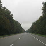
On the edge of Kansas and Missouri I set out to cross new territory. It rained all night, not too hard. The rain was never very serious all day today, but the clouds are. So thick and heavy overhead. A seriously gray day.
Driving on the interstate in this state makes me want to just keep going and going until I get home. The realization that I’m nearly finished with my trip hovered like the clouds and acceptance that this direction may hold some interesting experiences, but it is still the winding down.
Trucks provide ample interest. I enjoy unusual loads and think about all the stuff moving from here to there constantly. I think about the lives of truckers and how they manage to keep moving and maintaining their lives.
At one rest stop in Missouri a couple had taken their horse out of the trailer and couldn’t get it back in. The horse just refused to go back, no matter how much they pulled and prodded. I took a picture from inside the car and it just focused on the raindrops on the window, but the image is interesting.
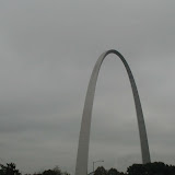
Driving through St. Louis was busy and although I could have stopped to see the arch, I felt like moving on. From the highway the beauty of the arch is crowded out by the billboards and a new thing that is like a moving picture in neon lights. These things should be outlawed.
Speaking of billboards, there is plenty of available space for advertisers along the route. Many of the billboards are begging for someone to advertise.
If you look at a map of Missouri you’ll see that all the state highways are letters and not numbers. That’s a twist. The land is lush and blanketed with trees. The hills are gentle and consistent. It looks a lot like the east coast.
The temperature never got above 48 degrees today. I think the high was around St. Louis. I knew I was in Illinois when the signs changed from a $10,000 fine for hitting a construction worker plus losing your license to a $10,000 fine and 14 years in prison. The land also flattened out and corn fields returned. I like Illinois. It feels good.
So I’ve settled down for the night at a Motel 6 alongside the highway. They are very cheap and not AAA approved, but clean and good enough. I don’t know how much more camping I’ll get to do if this cold keeps up.
I’m hoping for lots of leaf peeping the rest of the way. Most of the trees so far are beginning to turn with plenty of green still to make a very pleasant drive.
Subscribe to:
Posts (Atom)