 |
| Day 18 Photo Album |
September 20, 2009
Not feeling entirely enthused about Eureka, I avoided it until the afternoon. The day began extremely overcast and 60 degrees. But that doesn’t dampen the disposition of the inhabitants around here. They are cheerful and friendly.
While touring around Arcata, a very small town, I encountered many streets blocked off -- apparently there is something going on later today. So I set off for a few places north of Eureka that were recommended by some Texans I met in the forest yesterday.
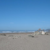
First stop was Moonstone Beach. This is the beach I saw yesterday with all the rocks jutting out of the ocean. The tide was about in the middle or rising, my best guess. I saw my first group of surfers, though they never got onto their feet. They seemed to just bob around in the ocean.
Further north is Patrick’s Point State Park in Trinidad. This gave me a very good idea of the near impossibility of camping in the state parks in California. The gatekeeper was extremely friendly and harried. The campers were sort of getting him flustered. He said the campgrounds were all filled up, very common in the State Parks.
I hiked down to Mussel Rock and found the trail full of ferns and steep stairs. It was worth the climb back up to see the waves crashing against the rocks. My next stop in the park was Patrick’s Point or Wedding Rock, maybe I could see both. You can hike out onto Wedding Rock, but I passed. Further on I stopped at Palmer’s Point where I could hear the sea lions barking out on the rocks. I could only see the specks of their bodies far away, but could hear them very well.
The temperature had still not reached 65 degrees and it was early afternoon. The sky finally cleared off about 11:30 in the morning, so the sun was brilliant and making a nice slightly foggy atmosphere.
I was going to head for some town further south when I chose to take a peek at Eureka’s downtown. I was pleasantly surprised by the area. The town is very spread out and mostly featureless, but the downtown area of about 5 blocks is in the mode of “old-town” as they call it. Better yet, I found two great natural grocery stores to get fresh fruit.
In forced spontaneous mode, I headed south with a few spots in my head that I may or may not explore.
Ferndale caught my attention so I left the Hwy 101 towards the coast 5 miles to this Victorian town. It really is quaint. I walked along the streets and spoke to one of the shop owners. She says they have no crime or derelicts (there were several in Eureka -- and she noted they have their share). It is farm country, but mostly dairy. Also in the Tsunami Hazard Zone. They have a huge tourist trade as well. The beach is another 5 miles from town and I got the tip to go beyond the lower parking lot to the top of the winding hill. Sure enough, the view from there was spectacular. This is The Lost Coast. It stretches way out of sight to the north and at the base under the cliffs is a small valley with a ranch nestled in it.
The sun was beginning to get low in the sky, so I thought I’d push on to Leggett where 101 meets 1. Unfortunately, I hit the wall and the sun was nearly hitting the horizon when I had to stop. Redcrest ushered me off the highway and into the coziest little spot where I have a very nice room in the middle of the redwood forest, on the Avenue of the Giants!
No comments:
Post a Comment
All comments are reviewed before publication. Please allow for a short delay.
If you don't see a message saying "Your comment will be visible after approval." then it didn't go through.
Try a different browser or send me your comment via e-mail.